





Summary
Although no blockbuster storms are in sight, the pattern remains active, with several chances for snow in the coming days. Higher snow levels will be a concern at the start of the workweek, but these storms should distribute snow fairly evenly across most of the Alps. The models continue to hint at a more significant pattern change later this month, but confidence remains low.
Short Term Forecast
I am not glued to every model run like I am when there’s a major storm on our doorstep, but for early November, frequent storms with no sign of persistent high pressure aren’t too bad. So, we will have several chances for accumulating snow in the next seven to ten days, and there are some signs of a more exciting pattern change later this month.
Before we get to these snow chances, and also the potential late-month pattern change, we have to push through the warm phase of the first storm that is underway today. Thanks to a slow-moving low-pressure system in the eastern Atlantic off the coast of Portugal, a warm southwesterly flow extends from the Atlantic into the central/soutghern Europe and the Alps. Below, you can see the low-pressure system meandering over the eastern Atlantic.
And here is the precipitable water anomaly overlaid on the upper-level pattern for today.

Fortunately, the low is out over the Atlantic, so rain totals aren’t expected to be that high for most of the Alps. The southwestern Alps should expect the most steady rain this week before cooler air arrives on Thursday night. In the next upper-level GIF, you can see a second low-pressure system dropping down from the north and absorbing some energy from the original low-pressure system in the eastern Atlantic.

The warm and wet southerly/southwesterly flow (snow levels ~ 2700 m) will transition to a more northerly flow as cooler air moves south. However, the exact track of the second low will determine how far west and south the cold air advances. The latest guidance keeps the coldest air on the eastern side of the Alps, so that’s where the heaviest snow is expected.
Snow levels will fall to around 1800 to 2100 m in the eastern Alps while the forcing remains consistent enough for precipitation. Farther west, snow levels should reach 2100 to 2400 m while the storm still has some juice. This is a solid cold front for early November, with snow levels dropping quite a bit further over the weekend, though moisture will be limited by that point. Still, the coldest air of the season is expected this wekeend, with snow levels bottoming out around 900 to 1200 m from east to west.
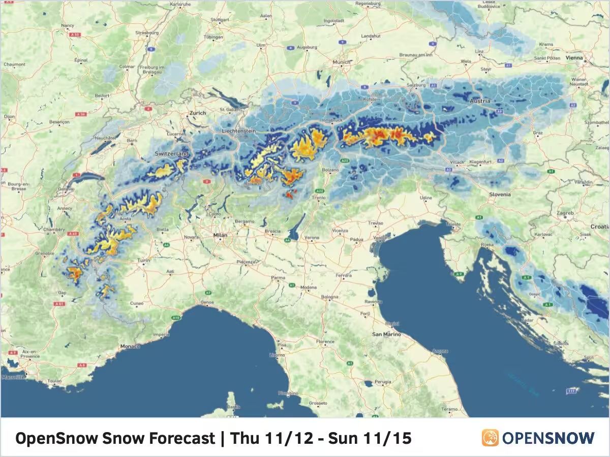
The latest snow forecast from the OpenSnow proprietary blend is shown below.

The Austrian glaciers and the inner Alpine zone in the Tirol region should do best, with 15 to 30 cm possible above 1800 m. Above 2100 m, 25 to 50 cm wouldn’t surprise me. Decent totals are expected across the border into Italy and Switzerland above 2400 m. Generally, the farther south and west you move from Austria, the warmer it will be and the higher you’ll have to go for accumulating snow. Accumulations will likely be limited under 2400 m in the northern French Alps, with lesser totals in the 10 to 20 cm range.
Extended Forecast
A break in the action is expected for most of the weekend, as a shortwave ridge moves into central Europe. Beyond that, the models begin to diverge quite a bit more. More storms will develop in the Atlantic and move into Europe. Some of the models bring these storms far enough south, with a strong and moist zonal flow pushing into the French Alps. However, some of the other models keep the upper-level trough farther north, limiting the impacts in the Alps.
The wetter zonal flow seems a bit more likely to me at this point, so I think the French Alps could do well in the Tuesday ot Thursday timeframe. It will be interesting to see which models are onto this pattern.
Next post will be on Wednesday.
Thanks for reading the Europe Daily Snow.
Luke Stone
Forecaster, OpenSnow
Announcements
2026-2027 Winter Release
We are excited to announce the following features and innovations, created in-house by our small team at OpenSnow.
These new features are currently available on the OpenSnow iOS app and website (OpenSnow.com). They are in development for the Android app and will be available soon.
Details: 2026-2027 Winter Release
Alps Regions:


Source: opensnow.com